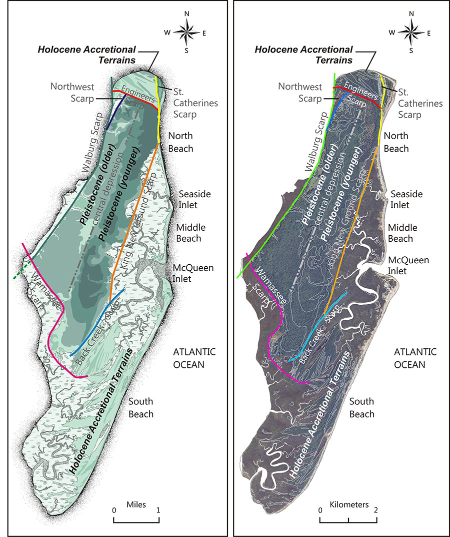
The island is comprised of three major geomorphic components: 1) Pleistocene island core, 2) Holocene accretional terrains, and 3) Holocene marshes (fig. GEO A).
GEO A
The island core is a relatively high topographic feature with little relief that occupies the western portion of the island complex and was previously assigned to the Silver Bluff Shoreline Complex (Hails and Hoyt, 1969). The Holocene accretional terrains are situated on the northern and southeastern portions of the island and consist of progradational beach ridge and swale sediments.
The island core is mostly composed of Late Pleistocene barrier island deposits initially assigned to the Silver Bluff Shoreline Complex (Hails and Hoyt, 1969). The island core reaches elevations of 5 to 7 meters above mean sea level with moderate to little relief and is slightly higher in elevation on the eastern portions of the core.
The three ridge and swale sediment packages that occur in the northern accretional terrains of St. Catherines Island are bounded or separated by three erosional boundaries or scarps designated as Northwest Scarp, Engineers Scarp, and St. Catherines Scarp.
The southeastern accretional terrains are separated from the island core by a series of scarps. The King New Ground Scarp separates the island core from the Holocene marsh deposits that are located to the east. An emarginated boundary has been developed by meandering tidal creeks eroding into the island core and has been designated as the King New Ground Emarginate Scarp (Bishop et al., 2007). Linear sets of beach ridges are also situated in the southeastern portion of the island and are separated from the island core by the Back Creek Scarp.
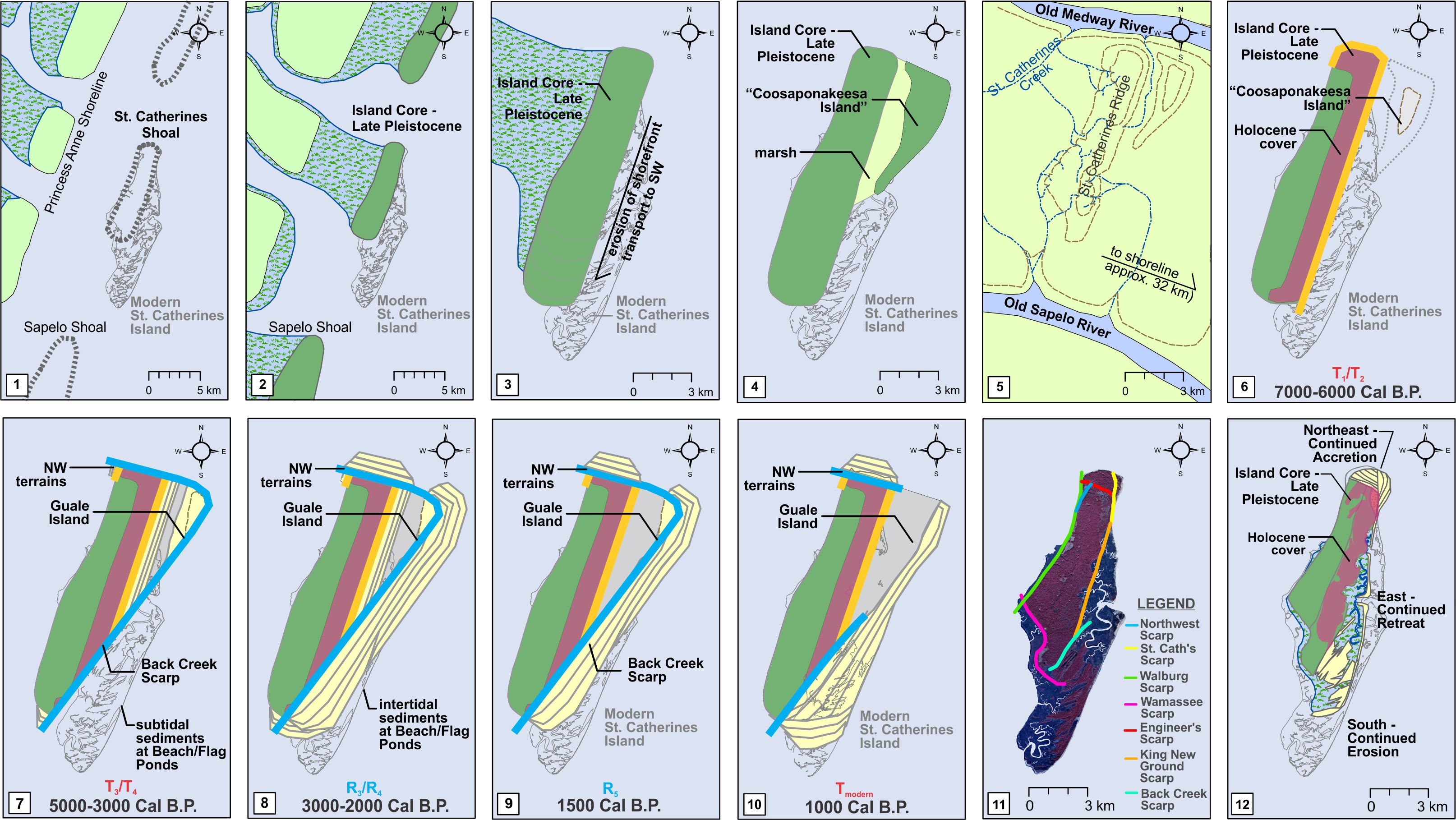
A conceptual model for the development of the island was initially formulated by Bishop and refined by Meyer, Vance and Bishop from 2009 to 2013 (Bishop et al., 2011; Meyer, 2013). The model is based on 12 sequential steps that are framed on the relative sequences of scarps, absolute dates of sediments, regional information regarding sea level, and several assumptions.
Based on the occurrence of eastern marshes and associated relict marsh muds on St. Catherines Island, an assumption was made during the development of the model that a barrier island formerly existed in the Late Holocene to the east of the current location of St. Catherines Island. Island couplets are observed on the Georgia coast such as the St. Simons–Sea Island or Sapelo–Blackbeard Island couplets, and it was assumed that a similar couplet with intervening salt marsh existed at St. Catherines Island prior to removal under the modern transgression. The hypothesized portion of the couplet was designated as Guale Island and incorporated into the island development model with the aforementioned scarps, absolute dates, results from local and regional studies and existing sea level information (fig. GEO B).
GEO B
Additional vibracoring conducted along the eastern margin of the island in 2010-2012 has identified another island couplet that may have existed during the Late Pleistocene. This island has been designated Coosaponakeesa Island (Meyer, 2013).
References
Bishop, G.A., Hayes, R.H., Meyer, B.K., Rollins, H.E., Rich, F.J., Thomas, D.H., and Vance R.K., 2007, Transgressive Barrier Island Features of St. Catherines Island, Georgia, In Rich F.J. (ed), Fieldtrips of the 2007 Annual Meeting, Southeastern Section, Geological Society of America. Georgia Southern University (Statesboro, GA), p. 39-85.
Bishop, G.A., B.K. Meyer, R.K. Vance, and F.J. Rich, 2011b. “Geoarchaeological Research at St. Catherine’s Island, Georgia: Defining the Geological Foundations.” Geoarchaeology of St. Catherines Island, Georgia, Anthropological Papers of the American Museum of Natural History, No. 94.
Hails, J.R. and J.H. Hoyt, 1969. An Appraisal of the Evolution of the Lower Atlantic Coastal Plain of Georgia, U. S. A. Transactions of the Institute of British Geographers, No. 46: 53-68.
Meyer BK (2013) Shoreline dynamics and environmental change under the modern transgression: St. Catherines Island, Georgia. PhD Dissertation, Georgia State University, Atlanta, GA
Master’s Theses
Knell, M.J., 2004, Taphonomy and ichnology of sea turtles from the Cretaceous Interior Sea- way of South Dakota. Master’s thesis, South Dakota School of Mines and Technology, Rapid City, 100 p.
McCurdy, C. 2009. Potential biasing of hatchling sex ratios of the loggerhead sea turtle, Caretta caretta, on St. Catherines Island, GA 2007: a pilot study. Master’s thesis, Georgia College and Sate University: 100 p.
Hart (Carrino) M., Taxonomic comparison and stratigraphic distribution of Toxochelys (Testudines: Cheloniidae) of South Dakota. M.S. Thesis, South dakota School of Mines and Technology.
Ph.D. Dissertations
Willis, Robert C. 2010. Conceptualizing Science Teacher Leadership — An Autonethnographic Study, University of Georgia, 130 pp.
Linsley, D. M. 1993. Depositional environments of St. Catherines Island: Their relationship to late Quaternary seal-level change and application to late Paleozoic cyclic stratigraphy. Ph.D. Dissertation, University of Pittsburgh, PA, 186 pp.
Robert Clayton Willis, 2010. Conceptualizing Science Teacher Leadership – An Autoethnographic Study, University of Georgia (Athens), 130 p.
Linsky, Catherine Lindsay Reed. 2012. Teachers’ Conceptualizations And Classroom Inclusion Of Ocean Literacy Following An Intensive Marine Science Professional Development Program University of Georgia (Athens), 326 P.
Meyer BK (2013) Shoreline dynamics and environmental change under the modern transgression: St. Catherines Island, Georgia. PhD Dissertation, Georgia State University, Atlanta, GA